


 The geometric documentation of a monument is defined as the action of acquiring, processing, presenting and recording the necessary data for the determination of the position and the actual existing form, shape and size of the monument in the three dimensional space at a particular given moment in time. Geometric documentation should be considered as an integral part of a greater action, the General Documentation of the Cultural Heritage. This comprises, among others, the historical documentation, the architectural documentation, the bibliographic documentation etc. All this wealth of information is usually stored, i.e. archived, in many forms. In the previous years analogue forms of archiving were employed, such as special monument cards.
During the last years the development of software for the management and presentation of geo-data has been rapidly increased. It is mentioned that there are more than 550 pieces of software available for terrain visualization (http://www.tec.army.mil/TD/tvd/survey/survey_toc.html) and a variety of software (ArcGIS/ArcView®, VirtualGIS®, Skyline®, TerrainView®, Maya® etc) for visualization and 3D GIS. Also, the 3D Engines, which is specific software that combines earth 3D model, images and vector data, is used for an ever increasing range of applications, among them cultural heritage management. These systems are freely distributed and include data from various space agencies (e.g., EuroImage, DigitalGlobe, NASA, WorldSAT etc), a 3D (which in reality is a 2.5D) or a 2D viewer and streaming technology. Some examples are: − Google Earth®, a 3D viewer with Quickbird high resolution satellite images in some areas and 3D city models of some cities − NASA Wind® (http://worldwind.arc.nasa.gov/), a 3D viewer of the NASA Blue Marble and Landsat data, terrain model from SRTM mission and high resolution satellite images over USA − EarthSLOT Web Interface® (http://eslot.engr.uaf.edu:8181/ eslot_web_interface.html), a 3D viewer of the NASA monthly data using Skyline 3D engine − VirtualEarth®, a 2D viewer with satellite data and aerial images over USA − GeoFusion®, Yawaha®, etc.
Most of these systems provide additional low cost commercial tools, like Google Earth Pro® and Google SketchUp Pro®, ArcGlobe® of ESRI, TerrainGlobe® of Viewtec, etc, where the user can import his own data, such as 3D models, vector layers and descriptive information. The use of open source software in cultural heritage management, in particular for non profit organisations and research centres, gives public access to a wide community of users to spatial cultural data. Several applications of open source web GIS are mentioned in international literature, such as the Appia Antica Project (http://www.appia.itabc.cnr.it) for the creation of a 3D spatial archive of the monuments of a wide archaeological park in Rome, through intense mapping, GIS and modelling activities using MapServer® software (http://mapserver.gis.umn.edu) and OpenSceneGraph (http://www.openscenegraph.org).
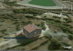
Aphroidte project is about the production of 3D reconstruction of historic monuments and their integration with the necessary attributes (historic information, images, etc.) in the web is described. The proper methodology for easy creation and presentation of 3D models, using Google Earth Pro and Google SketchUp software is developed. An application is made for the Painted Byzantine Churches of Troodos Mountain in Cyprus, which are included to the UNESCO list of World Heritage Monuments.